Topographic Point Quality
Topographic point quality calculations are derived from error evaluations which are conducted by extracting measurement data from the total station. Depending on the instrument software the measurement data is extracted from either a RAW file or an MJF file. These files contain the field measured horizontal angles, vertical angles and slope distances.
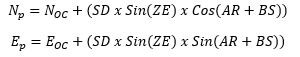
An error value is the difference between the original coordinate and a measured coordinate.
A measured coordinate is calculated as follows:
In the Champ GDB topo points shape file the point quality fields are VDE, HDE, and POINT_QUALITY. The analysis in a nutshell: Champ protocol requires a backsight before and after a series of topographic measurements are conducted. The horizontal and vertical errors are determined for both backsights and the largest horizontal and vertical error as well as the slope distance is logged. There is a relationship between the backsight errors and each topographic point measured. The error values associated with a measured point will increase or decrease relative to the distance to the instrument. The relationship is a simple proportion.
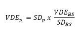
The vertical error for a point:
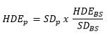
A similar calculation is used for the horizontal error for a point.
The horizontal error for a point:
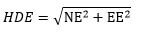
The horizontal error is comprised of two components, the northing error and the easting error.
The point quality is a 3 dimensional value derived from:
This is a fairly easy means to calculate a field observed error and use the values in an error raster for GIS or other data analysis further in the work flow. It is important to keep in mind that this is an error from one field station setup and that each survey usually contains multiple setups. Errors from each setup propagate to the next setup. There are errors that are not accounted for in this calculation, but we have fairly easily captured a significant portion of field error and incorporated said error into the data analysis.
The reduction of backsight errors in the field will translate to less error being applied to each point. If backsight errors are increasing during data collection the backsight error should be checked, to record the error in the file, and then the backsight can be reset, to record the reduced error in the file.
Additionally this proportional math for errors demonstrates that a long backsight and a short foresight are beneficial.
Where:
SD = Slope Distance
VDE = Vertical Distance Error
SD = Slope Distance
HDE = Horizontal Distance Error
ZE = Zenith
AR = Angle Right
BS = Backsight
p = for point
BS = for backsight
OC= point of occupation